Posts

Walking The Pennine Way When I Was Eleven - Stage 11: (Tan Hill to Middleton-in-Teesdale)

Stage Eleven Start: Tan Hill Finish:  Middleton-in-Teesdale Distance: 17 miles Total Distance Walked: 137 miles It says something about the relatively mundane nature of the walking on this stage that I can recall very little about it without the aid of a diary, which I had by this time neglected to keep.  Therefore this post is quite short. The first part of the day was walking across the heather of Sleightholme Moor.  It was fairly flat and uninteresting but fortunately the weather was as obliging as it had been on the rest of the Way and there were few difficulties.  Apparently this part of the walk can be unpleasant in wet conditions but having coped with the moors at the start of the Pennine Way when we hadn't been "walk-fit" these seemed easy enough on springy turf. The afternoon was a little more interesting in fields but I can't remember much about it.  We stayed in Middleton-in-Teesdale at a B & B following four nights under canvass....
Walking The Pennine Way When I Was Eleven - Stage 10: (Hawes to Tan Hill)

Start:  Hawes Finish:  Tan Hill Inn Distance: 17 miles Total Distance Walked: 120 miles At this point I stopped writing up my diary while I was doing the walk so my recollections are purely from my memories. We left Hawes and crossed fields for a mile until we reached the village of Hardraw.  There we took a short diversion off the Pennine Way to visit Hardraw Force, the highest waterfall in England at a height of 96 feet.  To reach it we had to go through the Green Dragon Inn, where we paid a small entrance fee, and walked along a path to the Force.  This was one of those rare spots on the route where other people were around and it was quite busy along the path. The waterfall itself was quite impressive in altitude, although not so much in volume.  We had been very lucky with the weather in the week or so we had been walking.  There had been some low cloud on Black Hill and it had been very windy at times but I can't recall having any ra...

Walking The Pennine Way When I Was Eleven - Stage 9: (Horton-in-Ribblesdale to Hawes)

Start: Horton-in-Ribblesdale Finish:  Hawes Distance: 15 miles Total Distance Walked: 103 miles After a breakfast of raspberry yoghurt we decamped and set off at 9.10.  The first few miles were easy walking on a well-surfaced, quite straight road with Pen-y-Ghent's distinct stepped profile on our right and Ingleborough's flat table-top summit to the left.  The route climbed steadily but took a course between the really high country on either side. After three miles the Way went into more open paths and we entered wilder terrain and saw a baby sparrowhawk.  We walked alongside Cam Beck and idled away some minutes watching a piece of foil drift along the Beck.  The ground became wetter underfoot on Cam Fell and at 12 we stopped at Cam End for lunch. The next notable climb was of Dodd Fell.  Although there were many of these hills on the Pennine Way I don't recall any of them being very arduous.  My father set a sensible pace and along the wa...

Walking The Pennine Way When I Was Eleven - Stage 8: (Malham to Horton-in-Ribblesdale)

Image
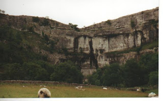
Start:  Malham Finish: Horton-in-Ribblesdale Distance: 12 miles Total Distance Walked:  88 miles We left our campsite just after 9 o'clock and were soon alongside a pleasant stream heading towards one of the most spectacular features of the whole route, Malham Cove.  This high limestone cliff, shining bright white, was once a waterfall higher than Niagara Falls. We climbed the path by the cove to reach the top and another page of our geography text books where we reached a limestone pavement.  This landscape of blocks of rock and fissures between them may have been interesting geologically but was awkward to walk on.  It was only a short section and we were then into attractive fields before reaching Malham Tarn. On this section of the Pennine way we had seen more people than on any so far and by the Tarn we mingled with a large group walking by the lake which is also a nature reserve.  Leaving the crowds behind we walked through m...

Walking The Pennine Way When I Was Eleven - Stage 7: (Thornton in Craven to Malham)

Start:  Thornton in Craven Finish:  Malham   Distance: 12 miles Total Distance Covered: 76 miles We had breakfast at the Post Office B & B .  I had Alpen, a poached egg on toast and bacon.  Before we left at 9.30 "Skinless", who we met the day before and had been camping in a field by the post office, told us that in the night a cow had put its foot through his tent.  We stocked up on supplies including for me a very exotic Yorkie Raisin and Biscuit chocolate bar, a new flavour. The route was much less remote than the early days of the walk.  Part of the route was easy and pleasant along the Leeds and Liverpool canal towpath.  At 12.15 we crossed stepping stones across the River Aire into the village of Gargrave where we had lunch.  While we were there we met the Family Party of walkers whom we had encountered a few days earlier. There was a bit of road walking after we left Gargrave which aggravated my blisters a little....

Walking The Pennine Way When I Was Eleven - Stage 6: (Stanbury Moor to Thornton in Craven)

Start: Stanbury Moor Finish: Thornton in Craven Distance: 12 miles Total Distance Walked: 64 miles We set off from our rough camp site on Stanbury Moor at 9 o'clock and soon joined a track and left the moor.  We departed from the official Pennine Way route to go to the village of Stanbury where we bought some postcards.  The road walking on this section hurt my feet. After this diversion which added a couple of miles to the rout we rejoined the Pennine Way for some rather uninspiring and cold walking across Ickornshaw Moor.  At 1.20 we came down into Cowling and stopped for lunch at the Black Bull where a sign invited walkers to remove their boots before entering. On the climb out of Cowling we were met by the sound of jet fighters flying low overhead.  Villages were now occurring on the route more often than in the early stages of the walk and only three miles after Cowling we reached Lothersdale where we stopped to buy refreshments.  I had a yogur...

pics lak

Image
In April 2009 I got the bus from Lancaster to Keswick and walked to Braithwaite before heading up into the hills.  I followed the flat track above Caudale Beck for two miles but didn't notice the path crossing the beck that I should have taken.  This meant that I found myself at the end of the valley having to scramble up a steep path by Low Force.  After that it was a pleasant day walking along the ridge to Hopegill Head and back to Grisedale Pike, which is a pleasing cone shaped mountain-top profile.  The decent to the Whinlatter Pass only took twenty minutes so I had time to look at the osprey camera at the visitor centre.  In June 2008 I resumed my Land's End to John O'Groats walk.  I had finished the previous stage in Scales after climbing Blencathra.  This left me with a ridiculously long stage from there to Carlisle if I wanted to avoid an extra trip from my sister's near Lancaster.  I go...