Posts

Showing posts with the label Long Distance Trails

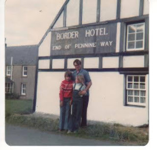
Walking The Pennine Way When I Was Eleven: Stage 18 - Cheviot Camp to Kirk Yetholm
Image
Start: Cheviot Camp Finish: Kirk Yetholm Distance Walked: 23 miles Total Distance Walked: 263 miles We were up at dawn to begin the long trek through the Cheviot hills and complete the Pennine Way. Much of the early part of the day was very close to the Border Fence between England and Scotland with views of the hills and valleys. We saw a mountain shelter hut in the distance. The path was decent, on grass and with the lack of rain wasn't too boggy. We saw very few people although as we neared the Cheviot later in the morning we weren't completely alone. The Cheviot is the highest point in the eponymous range of hills and lies a mile off the main Pennine Way route. The area around it is featureless and quite uninspiring with the summit rumoured to be wet and peaty. We weren't tempted to make the detour to the top and back. We climbed the last hill in England, Windy Gyle, before crossing the border for the last time and entering Scotland for good. ...

Walking the Pennine Way When I Was Eleven - Stage 17: Bellingham to Cheviot Camp

Start: Bellingham Finish: Cheviot Camp Distance: 20 miles . Total Distance Walked: 240 miles The first part of this stage I recall little of. It was through fields, moorland and another section of quite dull walking through conifer forests. The last bit of forest ended at the small village of Byrness, the last settlement before the end of the Pennine Way. We reached Byrness in the late afternoon and had a meal at the cafe there. Many walkers spend the night at Byrness and have a marathon slog of miles to finish the Way. My father had decided that this would be too much for us to do in one day so after eating we set off up out of Byrness into the Cheviot Hills. The first mile or two took us up through the last bit of woodland before we came out into the bare hills. We did another two miles and set up camp, as we had done on the first night of our walk, in wild hill country. Our camp was just next to a fence by a sign indicating MoD land. We listened to the radio and ...

Walking the Pennine Way When I Was Eleven - Stage 16: Once Brewed to Bellingham

Start: Once Brewed Finish: Bellingham Distance: 17 miles Total Distance Walked: 220 miles We left the busy campsite at Once Brewed, but as we did so said a final farewell to "Skinless" who we had met regularly since Day 6 of the walk. He had sustained an injury and had decided to rest for a day. We were soon at Hadrian's Wall and followed it on an undulating course for two miles. We had managed to stay on course nearly all the way but for a short distance here we took the wrong route. We found ourselves reaching a marshy area with tall reeds next to a small lake, Crag Lough, under a steep cliff close to the wall and realised we needed to retrace our steps to get up to the top of the hill. We left the Wall without making the short diversion to Housesteads fort as we needed to push on. I had started to feel a bit of pain in my hamstring and when I mentioned it my Dad said if it got worse we would stop the walk. As we had now done more than 200 miles I was ...

Walking the Pennine Way When I Was Eleven Stage 15: Slaggyford to Once Brewed

Start: Slaggyford Finish: Once Brewed Distance: 19 miles Total Distance Walked: 203 miles This was another of the less memorable stages of the walk. Most of it was through fields and moorland with little of note until the last few miles when we reached Hadrian's Wall. My main memories of this stage come from our overnight stopover. We were staying at a campsite at Once Brewed, about half a mile from the Wall. As it was again the weekend the campsite was busy. We went to the pub for our evening meal. While we were there a posh gentleman was trying to keep his unruly children, Charles and Henry, under control. These boys were a little younger than my sister and I, possibly nine and seven years old, and were behaving as boys of that age sometimes do. They were messing about and being a bit noisy which caused the pub's landlord to tell them off saying that by rights they shouldn't be in the pub. They calmed down a bit before leaving a little later. The camp...

Walking the Pennine Way When I Was Eleven Stage 14: Garrigill to Slaggyford

Start: Garrigill Finish: Slaggyford Distance: 10 miles Total Distance Walked: 184 miles We had breakfast at the Post Office B and B in Garrigill where the lady who ran it told us about her guests the previous day. They were foreign and weren't sure exactly what the black pudding they had enjoyed in their breakfast was. She had thanked them but hadn't felt able to explain to them. After two hard days walking we had an easier one in prospect. The morning mostly consisted of a gentle stroll close to the river South Tyne which here was a pleasant country watercourse. After four miles we reached Alston, the highest market town in England, which was one of the bigger places we had been to on the Pennine Way. We bumped into our old companion "Skinless" again and adjourned to a pub on the high street. It was a nice day and we sat outside for lunch. It was so nice there that we decided to stay there for a couple of hours, my sister and I drinking juices ...

Walking The Pennine Way When I Was Eleven: Stage 12 Middleton-in-Teesdale to Dufton

  Start:  Middleton-in-Teesdale Finish: Dufton Distance: 21 miles Total Distance Walked: 158 miles If the previous stage had been unmemorable this one was probably the finest of the entire walk.  It was the one we had been thinking about for days in the knowledge that it would be long and challenging.  Indeed it was, but it was also a lovely walk, mostly along the River Tees, with some fascinating sights on the way. We left Middleton and almost immediately were by the river walking upstream.  The first miles were pleasant but it was only after four miles that we reached the first notable feature, Low Force.  This is a group of small waterfalls which together make quite impressive rapids.  However, they are just the warm-up act for their big brother High Force, a mile along the Tees.  We could hear High Force from well downstream, the roar becoming louder until we could see the high cascade of the most impressive waterfall in England. A few days ea...

Walking The Pennine Way When I Was Eleven - Stage 11: (Tan Hill to Middleton-in-Teesdale)

Stage Eleven Start: Tan Hill Finish:  Middleton-in-Teesdale Distance: 17 miles Total Distance Walked: 137 miles It says something about the relatively mundane nature of the walking on this stage that I can recall very little about it without the aid of a diary, which I had by this time neglected to keep.  Therefore this post is quite short. The first part of the day was walking across the heather of Sleightholme Moor.  It was fairly flat and uninteresting but fortunately the weather was as obliging as it had been on the rest of the Way and there were few difficulties.  Apparently this part of the walk can be unpleasant in wet conditions but having coped with the moors at the start of the Pennine Way when we hadn't been "walk-fit" these seemed easy enough on springy turf. The afternoon was a little more interesting in fields but I can't remember much about it.  We stayed in Middleton-in-Teesdale at a B & B following four nights under canvass....

Walking The Pennine Way When I Was Eleven - Stage 10: (Hawes to Tan Hill)

Start:  Hawes Finish:  Tan Hill Inn Distance: 17 miles Total Distance Walked: 120 miles At this point I stopped writing up my diary while I was doing the walk so my recollections are purely from my memories. We left Hawes and crossed fields for a mile until we reached the village of Hardraw.  There we took a short diversion off the Pennine Way to visit Hardraw Force, the highest waterfall in England at a height of 96 feet.  To reach it we had to go through the Green Dragon Inn, where we paid a small entrance fee, and walked along a path to the Force.  This was one of those rare spots on the route where other people were around and it was quite busy along the path. The waterfall itself was quite impressive in altitude, although not so much in volume.  We had been very lucky with the weather in the week or so we had been walking.  There had been some low cloud on Black Hill and it had been very windy at times but I can't recall having any ra...

Walking The Pennine Way When I Was Eleven - Stage 9: (Horton-in-Ribblesdale to Hawes)

Start: Horton-in-Ribblesdale Finish:  Hawes Distance: 15 miles Total Distance Walked: 103 miles After a breakfast of raspberry yoghurt we decamped and set off at 9.10.  The first few miles were easy walking on a well-surfaced, quite straight road with Pen-y-Ghent's distinct stepped profile on our right and Ingleborough's flat table-top summit to the left.  The route climbed steadily but took a course between the really high country on either side. After three miles the Way went into more open paths and we entered wilder terrain and saw a baby sparrowhawk.  We walked alongside Cam Beck and idled away some minutes watching a piece of foil drift along the Beck.  The ground became wetter underfoot on Cam Fell and at 12 we stopped at Cam End for lunch. The next notable climb was of Dodd Fell.  Although there were many of these hills on the Pennine Way I don't recall any of them being very arduous.  My father set a sensible pace and along the wa...

Walking The Pennine Way When I Was Eleven - Stage 7: (Thornton in Craven to Malham)

Start:  Thornton in Craven Finish:  Malham   Distance: 12 miles Total Distance Covered: 76 miles We had breakfast at the Post Office B & B .  I had Alpen, a poached egg on toast and bacon.  Before we left at 9.30 "Skinless", who we met the day before and had been camping in a field by the post office, told us that in the night a cow had put its foot through his tent.  We stocked up on supplies including for me a very exotic Yorkie Raisin and Biscuit chocolate bar, a new flavour. The route was much less remote than the early days of the walk.  Part of the route was easy and pleasant along the Leeds and Liverpool canal towpath.  At 12.15 we crossed stepping stones across the River Aire into the village of Gargrave where we had lunch.  While we were there we met the Family Party of walkers whom we had encountered a few days earlier. There was a bit of road walking after we left Gargrave which aggravated my blisters a little....

Walking The Pennine Way When I Was Eleven - Stage 6: (Stanbury Moor to Thornton in Craven)

Start: Stanbury Moor Finish: Thornton in Craven Distance: 12 miles Total Distance Walked: 64 miles We set off from our rough camp site on Stanbury Moor at 9 o'clock and soon joined a track and left the moor.  We departed from the official Pennine Way route to go to the village of Stanbury where we bought some postcards.  The road walking on this section hurt my feet. After this diversion which added a couple of miles to the rout we rejoined the Pennine Way for some rather uninspiring and cold walking across Ickornshaw Moor.  At 1.20 we came down into Cowling and stopped for lunch at the Black Bull where a sign invited walkers to remove their boots before entering. On the climb out of Cowling we were met by the sound of jet fighters flying low overhead.  Villages were now occurring on the route more often than in the early stages of the walk and only three miles after Cowling we reached Lothersdale where we stopped to buy refreshments.  I had a yogur...

Walking The Pennine Way When I Was Eleven - Stage 5: (Mankinholes to Stanbury Moor)

Start: Mankinholes Finish: Stanbury Moor Distance: 12 miles Total Distance Walked: 52 miles After a windy night under canvas where I didn't get much sleep we got up at 7.30.  We set off at 9.45 and after a mile had reached the imposing tower of Stoodley Pike where the wind was still strong.  The monument commemmorates the Peace of Ghent in the Napoleonic Wars and can be seen from many miles away. From there we desecended to the Calder Valley.  There was a sense of reaching a new phase of the Pennine Way.  The first few days had been mostly across rather bleak moorland with few distinguishing features.  We entered the valley through woods having barely seen a tree for the last three days. We went through a hamlet called Eastwood and up a steep track.  A little later at Jack Bridge we stopped at the New Inn for lunch.  After the opening few days with nowhere to stop for refreshments mid-walk it was nice to have a meal and break. Leaving t...

Walking The Pennine Way When I Was Eleven - Stage 3 (Crowden to Marsden)

Start:  Crowden Finish:  Marsden Distance: 12 miles Total Distance Covered: 27 miles I was up at 7.45am the next morning for a breakfast of a vanilla drink concoction made from powder.  We left the campsite at 9.20 and set off along the main path out of the valley.  At some point we managed to drift off the official path and down to Crowden Great Brook.  We walked up the brook itself which although not very fast-flowing was still awkward as we stepped over rocks. Eventually we found a way uphill away from the brook onto some marshy ground and then a further steady climb to the top of Black Hill.  This is a barren wasteland of peat which is the highest point in Cheshire.  Except for the trig point on top it's pretty featureless, although there isn't much "pretty" about it.  There was low cloud by the time we approached the summit and visiblity was severely restricted.  We were able to see a group of two adults and children a little...

Walking The Pennine Way When I Was Eleven - Stage 2 (Red Brook to Crowden)

Start:  Red Brook Finish: Crowden Distance:  9 miles Total Distanced Covered:  15 miles The first morning of our walk and I was up at seven o'clock.  Breakfast  was nothing more than a drink called Rise and Shine, as I recall this was a powder that you mixed with water to make an orangy drink. After dismantling the tent we set off at nine o'clock out of the valley from the brook, immediately climbing steeply up to the Kinder Plateau to rejoin the official Pennine Way route.  We were soon going down again, leaving beside Kinder Downfall, a waterfall.  We sat nearby and got chatting to a warden from the Peak District National Park. The next stage saw us climb again to moorland and marsh on Bleaklow.  The conditions were pleasant and the path easy enough to follow and quite springy underfoot.  We had lunch on Featherbed Moss at 1.30. Many people find the section across the moors to Featherbed Moss tough but I didn't  have an...

Walking The Pennine Way When I Was Eleven - Stage 1 (Edale to Red Brook)

Start: Edale Finish:  Red Brook Distance Covered:  6 miles After making our preparations the summer holidays arrived and we were ready to go. So it was that on Saturday 14th July 1979 my parents, sister and myself set off from our home in Nottinghamshire at 2 o'clock.  At around half past three we reached Edale and at 3.55 said goodbye to my mother as we began our epic trek along the Pennine Way. My father had decided that it should be a gentle introduction to the walk so the first day was a relatively easy six miles.  The previous year we had walked across the plateau near Kinder Scout.  I remember it being a real struggle going over the peat cloughs and heather and hadn't been relishing the prospect of renewing the acquaintance.  The return visit wasn't anything like as difficult and I think we must have avoided the worst of it.  It was still quite testing terrain to face first up and after two hours reaching the Kinder plateau it took ano...

Walking the Pennine Way When I Was Eleven - Introduction and Preparations

In the summer of 1979 I walked the Pennine Way when I was eleven years old, along with my father and my sister who was nine.  The Pennine Way is the oldest and most famous long distance footpath in Britain running for 260 miles from Edale in Derbyshire to Kirk Yetholm in the Scottish borders through the Peak District, Pennines and Cheviots. I don't remember exactly when we decided to walk the Pennine Way but we had been told tales from when my father had walked it as a young man not long after it had been established. I also don't remember much of the planning for the walk.  We did one training walk of about five miles but that was it.  I do, however, remember quite a lot about the walk itself even though it was forty years ago.  I took a notebook to record a diary but only kept it up for a week.  The rest of this account is from my memories of the walk. For some reason we didn't take a camera so there aren't any photos from the walk itself. We all had ...